NASA Chooses American Companies to Transport U.S. Astronauts to International Space Station

U.S. astronauts once again will travel to and from the International Space Station from the United States on American spacecraft under groundbreaking contracts NASA announced Tuesday. The agency unveiled its selection of Boeing and SpaceX to transport U.S. crews to and from the space station using their CST-100 and Crew Dragon spacecraft, respectively, with a goal of ending the nation’s sole reliance on Russia in 2017.

"From day one, the Obama Administration made clear that the greatest nation on Earth should not be dependent on other nations to get into space," NASA Administrator Charlie Bolden said at the agency's Kennedy Space Center in Florida. "Thanks to the leadership of President Obama, the hard work of our NASA and industry teams, and support from Congress, today we are one step closer to launching our astronauts from U.S. soil on American spacecraft and ending the nation’s sole reliance on Russia by 2017. Turning over low-Earth orbit transportation to private industry will also allow NASA to focus on an even more ambitious mission – sending humans to Mars."
These Commercial Crew Transportation Capability (CCtCap) contracts are designed to complete the NASA certification for human space transportation systems capable of carrying people into orbit. Once certification is complete, NASA plans to use these systems to ferry astronauts to the International Space Station and return them safely to Earth.
The companies selected to provide this transportation capability and the maximum potential value of their FAR-based firm fixed-price contracts are:
-- The Boeing Company, Houston, $4.2 billion
-- Space Exploration Technologies Corp., Hawthorne, California, $2.6 billion
The contracts include at least one crewed flight test per company with at least one NASA astronaut aboard to verify the fully integrated rocket and spacecraft system can launch, maneuver in orbit, and dock to the space station, as well as validate all its systems perform as expected. Once each company’s test program has been completed successfully and its system achieves NASA certification, each contractor will conduct at least two, and as many as six, crewed missions to the space station. These spacecraft also will serve as a lifeboat for astronauts aboard the station.
NASA's Commercial Crew Program will implement this capability as a public-private partnership with the American aerospace companies. NASA's expert team of engineers and spaceflight specialists is facilitating and certifying the development work of industry partners to ensure new spacecraft are safe and reliable.
For more information about NASA's Commercial Crew Program and CCtCap, visit:

Five Things About NASA's ISS-RapidScat

NASA's ISS-RapidScat mission will observe ocean wind speed and direction over most of the globe, bringing a new eye on tropical storms, hurricanes and typhoons. Here are five fast facts about the mission.

1. The space station looks homeward. ISS-RapidScat is the first scientific Earth-observing instrument specifically designed and developed to mount on the exterior of the International Space Station.
2. Microwaves in space. The ISS-RapidScat scatterometer is a type of radar that uses the same low-energy microwaves you use to warm up food. It bounces the microwaves off the ocean surface and analyzes the strength of the return signal to calculate wind speed and direction over the ocean.
3. Great sightlines, tight deadlines. The entire mission was built in a mere 18 months to catch a free ride on a scheduled International Space Station cargo resupply mission and take advantage of an available mounting location on the station. Most free-flying satellite missions require many years in development before launch.
4. Reduce, reuse, recycle. The ISS-RapidScat team adapted and reused hardware from the 1990s that was built to test the preceding NASA scatterometer instrument, QuikScat. Despite their advanced age, the components offer all the capacity the mission needs and passed every test. Using these components significantly reduced the mission’s overall cost.
5. A view that changes daily. Two other satellite instruments record ocean winds, but they are in sun-synchronous orbit, meaning that they cross the equator at the same times each day. The space station's orbit will take ISS-RapidScat across almost the entire globe between the Arctic and Antarctic circles at different times of the day. This will give scientists data they need to study how ocean winds grow and change throughout the day.
For more information about ISS-RapidScat, please visit:
More information about NASA's Earth science activities this year is at:

NASA Mars Spacecraft Ready for Sept. 21 Orbit Insertion

NASA’s Mars Atmosphere and Volatile Evolution (MAVEN) spacecraft is nearing its scheduled Sept. 21 insertion into Martian orbit after completing a 10-month interplanetary journey of 442 million miles.

Flight Controllers at Lockheed Martin Space Systems in Littleton, Colorado, will be responsible for the health and safety of the spacecraft throughout the process. The spacecraft’s mission timeline will place the spacecraft in orbit at approximately 9:50 p.m. EDT.
“So far, so good with the performance of the spacecraft and payloads on the cruise to Mars,” said David Mitchell, MAVEN project manager at NASA’s Goddard Space Flight Center in Greenbelt, Maryland. “The team, the flight system, and all ground assets are ready for Mars orbit insertion.”
The orbit-insertion maneuver will begin with the brief firing of six small thruster engines to steady the spacecraft. The engines will ignite and burn for 33 minutes to slow the craft, allowing it to be pulled into an elliptical orbit with a period of 35 hours.
Following orbit insertion, MAVEN will begin a six-week commissioning phase that includes maneuvering the spacecraft into its final orbit and testing its instruments and science-mapping commands. Thereafter, MAVEN will begin its one-Earth-year primary mission to take measurements of the composition, structure and escape of gases in Mars’ upper atmosphere and its interaction with the sun and solar wind.
“The MAVEN science mission focuses on answering questions about where did the water that was present on early Mars go, about where did the carbon dioxide go,” said Bruce Jakosky, MAVEN principal investigator from the University of Colorado, Boulder's Laboratory for Atmospheric and Space Physics. “These are important questions for understanding the history of Mars, its climate, and its potential to support at least microbial life.”
MAVEN launched Nov. 18, 2013, from Cape Canaveral, Florida, carrying three instrument packages. It is the first spacecraft dedicated to exploring the upper atmosphere of Mars. The mission’s combination of detailed measurements at specific points in Mars’ atmosphere and global imaging provides a powerful tool for understanding the properties of the Red Planet’s upper atmosphere.
“MAVEN is another NASA robotic scientific explorer that is paving the way for our journey to Mars,” said Jim Green, director of the Planetary Science Division at NASA Headquarters in Washington. “Together, robotics and humans will pioneer the Red Planet and the solar system to help answer some of humanity’s fundamental questions about life beyond Earth.”

NASA Airborne Campaigns Focus on Climate Impacts in the Arctic

This red plane is a DHC-3 Otter, the plane flown in NASA's Operation IceBridge-Alaska surveys of mountain glaciers in Alaska.


Over the past few decades, average global temperatures have been on the rise, and this warming is happening two to three times faster in the Arctic. As the region’s summer comes to a close, NASA is hard at work studying how rising temperatures are affecting the Arctic.

NASA researchers this summer and fall are carrying out three Alaska-based airborne research campaigns aimed at measuring greenhouse gas concentrations near Earth’s surface, monitoring Alaskan glaciers, and collecting data on Arctic sea ice and clouds. Observations from these NASA campaigns will give researchers a better understanding of how the Arctic is responding to rising temperatures.

The Arctic Radiation – IceBridge Sea and Ice Experiment, or ARISE, is a new NASA airborne campaign to collect data on thinning sea ice and measure cloud and atmospheric properties in the Arctic. The campaign was designed to address questions about the relationship between retreating sea ice and the Arctic climate.

Cleaner NASA Rover Sees Its Shadow in Martian Spring

Late afternoon lighting produced a dramatic shadow of NASA's Mars Exploration Rover Opportunity photographed by the rover's rear hazard-avoidance camera on March 20, 2014.


The shadow falls across a slope called the McClure-Beverlin Escarpment on the western rim of Endeavour Crater, where Opportunity is investigating rock layers for evidence about ancient environments.  The scene includes a glimpse into the distance across the 14-mile-wide (22-kilometer-wide) crater.
The rover experienced a partial cleaning of dust from its solar panels by Martian wind this week, boosting electrical output from the array by about 10 percent, following a similar event last week. That is in addition to increased sunshine each day in the Martian southern hemisphere's early spring. Combined, the seasonal effect and multiple dust-cleaning events have increased the amount of energy available each day from the rover's solar array by more than 70 percent compared with two months ago, to more than 615 watt hours.
On March 23, 2004, when Opportunity had been working on Mars for only two months, scientists announced the mission's headline findings of evidence for water gently flowing across the surface of an area of Mars billions of years ago.
During Opportunity's first decade on Mars and the 2004-2010 career of its twin, Spirit, NASA's Mars Exploration Rover Project yielded a range of findings proving wet environmental conditions on ancient Mars -- some very acidic, others milder and more conducive to supporting life.

Research Clarifies Health Costs of Air Pollution from Agriculture

Ammonia pollution from agricultural sources poses larger health costs than previously estimated, according to NASA-funded research.


Harvard University researchers Fabien Paulot and Daniel Jacob used computer models including a NASA model of chemical reactions in the atmosphere to better represent how ammonia interacts in the atmosphere to form harmful particulate matter. The improved simulation helped the scientists narrow in on the estimated health costs from air pollution associated with food produced for export – a growing sector of agriculture and a source of trade surplus.
"The 'cost' is an economic concept to measure how much people are willing to pay to avoid a risk," Paulot said. "This is used to quantify the cost for society but also to evaluate the benefits of mitigation."
The new research by Paulot and Jacob calculate the health cost associated with the ammonia emissions from agriculture exports to be $36 billion a year – equal to about half of the revenue generated by those same exports – or $100 per kilogram of ammonia. The study was published December 2013 in Environmental Science & Technology.
The new estimate is about double the current estimate by the U.S. Environmental Protection Agency, which suggests a cost of $47 per kilogram of ammonia. The scientists say the new estimate is on the high end of the spectrum, which reflects the need for more research into characterizing the relationship between agricultural ammonia emissions and the formation of the harmful fine particulate matter – a relationship that's not as straightforward as previous estimates assumed.
"The effect of ammonia on fine particulate is complex, and we believe that the models previously used in the United States to price ammonia emissions have not captured this well," Paulot said.

NASA's Last F-104 Makes its Final Flight 20 Years Ago

NASA research pilot Tom McMurtry advanced the throttle of the sleek F-104 as it streaked across Rogers Dry Lake at Edwards Air Force Base, barely a few hundred feet above the lakebed. With hundreds of employees gathered atop the main administration building and the ramp area, McMurtry piloted NASA 826 toward NASA's Dryden Flight Research Center, with the airspeed indicator reading 450 knots.


That was the scenario on Feb. 3, 1994, 20 years ago this week at NASA Dryden. After 1,415 flights, NASA 826, one of three F-104G aircraft obtained by NASA from the German Luftwaffe in 1975, had flown its last. It would soon be retired and placed on display outside the center than had been its home for the preceding 19 years. It remains on exhibit today.

McMurtry's final flyover in NASA 826, which was preceded by a high-altitude pass at supersonic speed with a window-rattling sonic boom followed by a low-level flyby at a fairly pedestrian – for an F-104 – 275 knots, brought to an end 38 years of service by 11 F-104s at NASA Dryden. It was a fitting tribute.
"The sky cleared up just in time for F-104 826's last flight," reads the anonymous entry in NASA Dryden's Flight Operations log for the date. "Tom put on a beautiful show with a high, supersonic flyover, and two low, high-speed passes over Bldg. 4800."

Originally designed by Kelly Johnson and his team at Lockheed's "Skunk Works" as a day fighter/interceptor for the U.S. Air Force, the F-104 Starfighters later found other uses as low-level, high-speed fighter-bombers in the air forces of several nations. NASA acquired its first F-104A from the Air Force in August 1956, and the versatile high-performance aircraft soon proved to be ideal for both research, mission support and pilot training, becoming the workhorses in NASA's small stable of high-speed research aircraft.

Early on, a modified F-104 tested the reaction control thrusters for the hypersonic X-15 rocket plane. The F-104's short wings and low lift-to-drag ratio enabled it to simulate the X-15's landing profile, which pilots often undertook in F-104s before X-15 flights to acquaint them with the rocket plane's landing characteristics. This training role continued with the lifting bodies. NASA's F-104s were also used for high-speed research after the X-1E was retired. Lockheed built three of the aircraft specifically for NASA's requirements, and they were given the F-104N designation.

Two of NASA's F-104s were lost in crashes, including one that cost the life of the center's chief pilot Joseph Walker, following a mid-air collision with an XB-70 in 1966.NASA 826, officially registered as N826NA, accomplished a wide-range of research activities, including tests of the Space Shuttle's Thermal Protection System tiles during its 19 years at the center. But its days were numbered.

Difficulty in maintaining and obtaining parts for the aging F-104 fleet led NASA to make the decision to retire the last of the aircraft in favor of newer, more maneuverable F-18s and F/A-18s, early models of which had become available from the Navy's test fleet. Over the course of almost 38 years, from August 1956 through February 1994, the 11 F-104s flown by NASA had accumulated over 18,000 flights at NASA Dryden in a great variety of missions ranging from basic research to airborne simulation and service as an aerodynamic test bed.

Looking Back to the Cradle of Our Universe

NASA's Spitzer and Hubble Space Telescopes have spotted what might be one of the most distant galaxies known, harkening back to a time when our universe was only about 650 million years old (our universe is 13.8 billion years old). The galaxy, known as Abell2744 Y1, is about 30 times smaller than our Milky Way galaxy and is producing about 10 times more stars, as is typical for galaxies in our young universe.


The discovery comes from the Frontier Fields program, which is pushing the limits of how far back we can see into the distant universe using NASA's multi-wavelength suite of Great Observatories. Spitzer sees infrared light, Hubble sees visible and shorter-wavelength infrared light, and NASA's Chandra X-ray Observatory sees X-rays. The telescopes are getting a boost from natural lenses: they peer through clusters of galaxies, where gravity magnifies the light of more distant galaxies.

The Frontier Fields program will image six galaxy clusters in total. Hubble images of the region are used to spot candidate distant galaxies, and then Spitzer is needed to determine if the galaxies are, in fact, as far as they seem. Spitzer data also help determine how many stars are in the galaxy.

These early results from the program come from images of the Abell 2744 galaxy cluster. The distance to this galaxy, if confirmed, would make it one of the farthest known. Astronomers say it has a redshift of 8, which is a measure of the degree to which its light has been shifted to redder wavelengths due to the expansion of our universe. The farther a galaxy, the higher the redshift. The farthest confirmed galaxy has a redshift of more than 7. Other candidates have been identified with redshifts as high as 11.

"Just a handful of galaxies at these great distances are known," said Jason Surace, of NASA's Spitzer Science Center at the California Institute of Technology, Pasadena. "The Frontier Fields program is already working to find more of these distant, faint galaxies. This is a preview of what's to come."

The findings, led by astronomers from the Instituto de Astrofísica de Canarias and La Laguna University, are accepted for publication in the scientific journal Astronomy and Astrophysics Letters.

Radar Study of Icelandic Glacier Winter Movement - by NASA

The cold of an Icelandic winter did not stop one NASA science aircraft from completing a mission to map glaciers on the island during the past week. NASA's C-20A, based at the Dryden Aircraft Operations Facility in Palmdale, Calif., flew four radar missions from Keflavik International Airport near Reykjavik, Iceland.


The aircraft carries a precision NASA synthetic aperture radar, developed by the Jet Propulsion Laboratory in Pasadena, Calif., that uses a technique called interferometric synthetic aperture radar (InSAR) to detect and measure very subtle deformations in Earth's surface.

A ground crewman at Keflavik International Airport sprays de-icing fluid on NASA's C-20A research aircraft prior to takeoff on a radar imaging mission over Iceland's glaciers. The aircraft was parked outside overnight in sub-freezing temperatures, requiring de-icing each morning.

The Icelandic mission is designed to study how movement of the glaciers in winter differs from their movement in summer when there is considerable meltwater that reaches the bed of the glacier, according to principal investigator Mark Simons, a professor of geophysics at the California Institute of Technology in Pasadena. "This study will help scientists better understand the basic processes that control the fate of glaciers as climate changes. In so doing, this study contributes to our understanding of glacier behavior world wide and will aid in improving our estimates of rising sea levels," said Simons.

"We all recognize that the techniques being developed in this project both observationally and in terms of modeling should have significant impact on studies of the cryosphere around the globe, as well as on our planning for a future U.S. L-band radar satellite," he added.


The Uninhabited Aerial Vehicle Synthetic Aperture Radar (UAVSAR) is installed in a specialized pod mounted on the belly of NASA's aircraft. Each of the four flights, totaling more than 26 hours, was flown over the same path as a summer 2012 study of surface ice on glaciers.

Prior to the first science mission being flown Jan. 31, the C-20A had to be de-iced after being parked outside overnight due to lack of hangar space. When the crew arrived to prepare for flight, the "aircraft looked remarkably like a glazed donut," quipped NASA C-20A project manager John McGrath.

The C-20A, which is a military version of the civilian Gulfstream III business aircraft, and its specialized equipment arrived back in the U.S. Feb. 6.

Looking Back at How NASA Looked Ahead during 2013

Focusing on the future was the dominant theme of a busy year for NASA's aeronautical innovators during 2013.
A new strategic vision that will guide the agency's aviation research efforts now and into the future was adopted even as world class research continued at NASA centers across the nation to make air travel ever more efficient and environmentally friendly.
"This has been a truly incredible year for us as our entire team continued making exciting technical advances that show great promise for positively impacting our nation’s economy and job growth," said Jaiwon Shin, NASA's associate administrator for aeronautics.
"The future of aviation in this country is going to be even more remarkable thanks to the plans made and work we accomplished during 2013," Shin said.
Here are highlights of what NASA Aeronautics has done during the past year to improve aviation.


Based on a fresh look at the future of aviation – as well as global trends in technology, the environment and economics – NASA Aeronautics chartered a new strategic vision for its aviation research programs.
The updated vision is designed to ensure that, through NASA's aeronautics research, the United States will maintain its leadership in the sky, and sustain aviation so that it remains a key economic driver and cultural touchstone for the nation.


What this means for the flying public is that NASA's contributions to aviation will be even more relevant as ongoing research leads to new aircraft, improved mobility and safety, less impact on the environment, and an all-around better experience in the sky.

More Efficient Highways in the Sky
NASA is working with the Federal Aviation Administration (FAA) and others to modernize the nation's air traffic control system with the help of new technology, software and procedures – an effort known as NextGen.

The technology behind one such tool, which was transferred to the FAA during 2013, is intended to help controllers determine the best time to release an airliner from its gate so it can taxi, takeoff and join a specific slot in the traffic flow overhead.

Known as the Precision Departure Release Capability, it is intended to work with other traffic management tools and will help controllers react more quickly when conditions change because of weather or other problems.

For more
http://www.nasa.gov/2013_highlights/#.UuyBd_vLGSo

NASA Picks Space Station Science Research Proposals

NASA's Physical Science Research Program will fund seven proposals, including one from NASA's Jet Propulsion Laboratory, Pasadena, Calif., to conduct physics research using the agency's new microgravity laboratory, which is scheduled to launch to the International Space Station in 2016.


NASA's Cold Atom Laboratory (CAL) will provide an opportunity to study ultra-cold quantum gases in the microgravity environment of the space station -- a frontier in scientific research that is expected to reveal interesting and novel quantum phenomena.

This environment makes it possible to conduct research in a way unachievable on Earth because atoms can be observed over a longer period, and mixtures of different atoms can be studied free of the effects of gravity, where cold atoms can be trapped more easily by magnetic fields.

The chosen proposals came from seven research teams, which include three Nobel laureates, in response to NASA's research announcement "Research Opportunities in Fundamental Physics." The proposals will receive a total of about $12.7 million over a four- to five-year period. Development of selected experiments will begin immediately.

Five of the selected proposals will involve flight experiments using CAL aboard the space station, following ground-based research activities to prepare the experiments for flight. Two of the selected proposals call for ground-based research to help NASA plan for future flight experiments. The Cold Atom Laboratory project office is at JPL, which is developing the instrument in-house. CAL is a joint partnership of JPL, NASA's International Space Station Program Office at the Johnson Space Center in Houston, and the Space Life and Physical Sciences Branch at NASA Headquarters.

NASA Mars Rover's View of Possible Westward Route

NASA's Curiosity Mars rover reached the edge of a dune on Jan. 30 and photographed the valley on the other side, to aid assessment of whether to cross the dune.


Curiosity is on a southwestward traverse of many months from an area where it found evidence of ancient conditions favorable for microbial life to its long-term science destination on the lower slopes of Mount Sharp. Based on analysis of images taken from orbit by NASA's Mars Reconnaissance Orbiter, a location dubbed "Dingo Gap" was assessed as a possible gateway to a favorable route for the next portion of the traverse.

A dune across Dingo Gap is about 3 feet (1 meter) high, tapered off at both sides of the gap between two low scarps. Curiosity reached the eastern side of the dune on Jan. 30 and returned images that the rover team is using to guide decisions about upcoming drives.

NASA's Mars Science Laboratory Project is using Curiosity to assess ancient habitable environments and major changes in Martian environmental conditions. JPL, a division of the California Institute of Technology in Pasadena, built the rover and manages the project for NASA's Science Mission Directorate in Washington.

Nasa Space news - Rosetta: To Chase a Comet

Comets are among the most beautiful and least understood nomads of the night sky. To date, half a dozen of these most heavenly of heavenly bodies have been visited by spacecraft in an attempt to unlock their secrets. All these missions have had one thing in common: the high-speed flyby. Like two ships passing in the night (or one ship and one icy dirtball), they screamed past each other at hyper velocity -- providing valuable insight, but fleeting glimpses, into the life of a comet. That is, until Rosetta.


NASA is participating in the European Space Agency's Rosetta mission, whose goal is to observe one such space-bound icy dirt ball from up close -- for months on end. The spacecraft, festooned with 25 instruments between its lander and orbiter (including three from NASA), is programmed to "wake up" from hibernation on Jan. 20. After a check-out period, it will monitor comet 67P/Churyumov-Gerasimenko as it makes its nosedive into, and then climb out of, the inner solar system. Over 16 months, during which old 67P is expected to transform from a small, frozen world into a roiling mass of ice and dust, complete with surface eruptions, mini-earthquakes, basketball-sized, fluffy ice particles and spewing jets of carbon dioxide and cyanide.

"We are going to be in the cometary catbird seat on this one," said Claudia Alexander, project scientist for U.S. Rosetta from NASA's Jet Propulsion Laboratory in Pasadena, Calif.  "To have an extended presence in the neighborhood of a comet as it goes through so many changes should change our perspective on what it is to be a comet."

Since work began on Rosetta back in 1993, scientists and engineers from all over Europe and the United States have been combining their talents to build an orbiter and a lander for this unique expedition.  NASA's contribution includes three of the orbiter's instruments (an ultraviolet spectrometer called Alice; the Microwave Instrument for Rosetta Orbiter; and the Ion and Electron Sensor. NASA is also providing part of the electronics package for an instrument called the Double Focusing Mass Spectrometer, which is part of the Swiss-built Rosetta Orbiter Spectrometer for Ion and Neutral Analysis instrument. NASA is also providing U.S. science investigators for selected non-U.S. instruments and is involved to a greater or lesser degree in seven of the mission's 25 instruments. NASA's Deep Space Network provides support for ESA's Ground Station Network for spacecraft tracking and navigation.

"All the instruments aboard Rosetta and the Philae lander are designed to work synergistically," said Sam Gulkis of JPL, the principal investigator for the Microwave Instrument for Rosetta Orbiter. "They will all work together to create the most complete picture of a comet to date, telling us how the comet works, what it is made of, and what it can tell us about the origins of the solar system."

The three NASA-supplied instruments are part of the orbiter's scientific payload. Rosetta's Microwave Instrument for Rosetta Orbiter specializes in the thermal properties. The instrument combines a spectrometer and radiometer, so it can sense temperature and identify chemicals located on or near the comet's surface, and even in the dust and ices jetting out from it. The instrument will also see the gaseous activity through the dusty cloud of material.  Rosetta scientists will use it to determine how different materials in the comet change from ice to gas, and to observe how much it changes in temperature as it approaches the sun.

Like the Microwave for Rosetta Orbiter, the Alice instrument contains a spectrometer. But Alice looks at the ultraviolet portion of the spectrum. Alice will analyze gases in the coma and tail and measure the comet’s production rates of water and carbon monoxide and dioxide. It will provide information on the surface composition of the nucleus, and make a potentially key measurement of argon, which will be a big clue about what the temperature was in the primordial solar system when the comet's nucleus originally formed (more than 4.6 billion years ago).

Magnetic Arcs

An M5 flare (medium-size) associated with a coronal mass ejection generated a fairly robust radiation storm (May 22-23, 2013). The outburst originated from active region right near the right edge of the Sun. After the eruption, cascades of magnetic loops spun up above the area as the magnetic fields tried to reorganize themselves. When viewed in profile, they put on a marvelous display of solar activity. The images are a combination of two wavelengths of extreme ultraviolet light (at 171 and 304 Angstroms). Credit: NASA's Solar Dynamics Observatory.

Swirls along an Ice Highway - Nasa Images

Sea water off the east coast of Greenland looked a bit like marbled paper in October 2012. The shifting swirls of white were sea ice, as observed by the Moderate Resolution Imaging Spectroradiometer (MODIS) on NASA’s Aqua satellite on October 17, 2012. In fact, this ice moved discernibly between October 16 and October 17. Thin, free-drifting ice moves very easily with winds and currents.


Each year, Arctic sea ice grows through the winter, reaching its maximum extent around March. It then melts through the summer, reaching its minimum in September. By October, Arctic waters start freezing again. However, the ice in the image above is more likely a remnant of old ice that migrated down to the coast of Greenland. Sea water is unlikely to start freezing this far south in October.


Along Greenland’s east coast, the Fram Strait serves as an expressway for sea ice moving out of the Arctic Ocean. The movement of ice through the strait used to be offset by the growth of ice in the Beaufort Gyre. Until the late 1990s, ice would persist in the gyre for years, growing thicker and more resistant to melt. Since the start of the twenty-first century, however, ice has been less likely to survive its trip through the southern part of the Beaufort Gyre. As a result, less Arctic sea ice has been able to pile up and form multi-year ice.

With less thick ice there is less Arctic sea ice volume, something the researchers at the Polar Science Center at the University of Washington have modeled from 1979 to 2012. Their results appear in the graph above. The model indicates that ice volume peaks in March through May of each year and reaches its lowest levels from August through October. But while the seasonal timing of the peaks and valleys has remained consistent since 1979, the total sea ice volume has declined.

The thick blue line is the 1979–2000 average, and the lighter blue bands surrounding it are one and two standard deviations from the median. The lines below the blue line are the calculated sea ice volumes for the years since 2000. All of them fall below the median, and almost all of them fall below two standard deviations.

The drop in sea ice volume is consistent with other observed changes in Arctic sea ice. In terms of sea ice extent, the National Snow and Ice Data Center and NASA reported that Arctic sea ice set a record low in September 2012.

NASA Released January Solar Flare Images

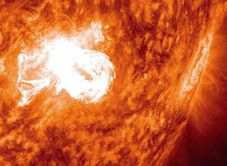
The sun emitted a mid-level solar flare, peaking at 5:13 a.m. EST on Jan. 7, 2014. Images of the flare were captured by NASA's Solar Dynamics Observatory and showed that it came from an active region on the sun that currently sports one of the largest sunspots seen in the last 10 years. Sunspots are regions of strong and complex magnetic fields on the sun's surface.


Solar flares are powerful bursts of radiation. Harmful radiation from a flare cannot pass through Earth's atmosphere to physically affect humans on the ground, however -- when intense enough -- they can disturb the atmosphere in the layer where GPS and communications signals travel.


To see how this event may impact Earth, please visit NOAA's Space Weather Prediction Center at http://spaceweather.gov, the U.S. government's official source for space weather forecasts, alerts, watches and warnings.

This flare is classified as an M7.2-class flare.

Swilling Stormy Stars present on cool celestial orbs

Swirling, stormy clouds may be ever-present on cool celestial orbs called brown dwarfs. New observations from NASA's Spitzer Space Telescope suggest that most brown dwarfs are roiling with one or more planet-size storms akin to Jupiter's "Great Red Spot." "As the brown dwarfs spin on their axis, the alternation of what we think are cloud-free and cloudy regions produces a periodic brightness variation that we can observe," said Stanimir Metchev of the University of Western Ontario, Canada. "These are signs of patchiness in the cloud cover."


In a Spitzer program named "Weather on Other Worlds," astronomers used the infrared space telescope to watch 44 brown dwarfs as they rotated on their axis for up to 20 hours. Previous results had suggested that some brown dwarfs have turbulent weather, so the scientists had expected to see a small fraction vary in brightness over time. However, to their surprise, half of the brown dwarfs showed the variations. When you take into account that half of the objects would be oriented in such a way that their storms would be either hidden or always in view and unchanging, the results indicate that most, if not all, brown dwarfs are racked by storms.

"We needed Spitzer to do this," said Metchev. "Spitzer is in space, above the thermal glow of the Earth's atmosphere, and it has the sensitivity required to see variations in the brown dwarfs' brightness."
The results led to another surprise as well. Some of the brown dwarfs rotated much more slowly than any previously measured, a finding that could not have been possible without Spitzer's long, uninterrupted observations from space. Astronomers had thought that brown dwarfs sped up to very fast rotations when they formed and contracted, and that this rotation didn't wind down with age.

"We don't yet know why these particular brown dwarfs spin so slowly, but several interesting possibilities exist," said Heinze.  "A brown dwarf that rotates slowly may have formed in an unusual way -- or it may even have been slowed down by the gravity of a yet-undiscovered planet in a close orbit around it."

The work may lead to a better understanding of not just brown dwarfs but their "little brothers": the gas-giant planets. Researchers say that studying the weather on brown dwarfs will open new windows onto weather on planets outside our solar system, which are harder to study under the glare of their stars. Brown dwarfs are weather laboratories for planets, and, according to the new results, those laboratories are everywhere.

Orbital Launch Rescheduled for Jan. 8 - Nasa Space news

The International Space Station Program and Orbital Sciences Corporation have decided to postpone the launch of the Antares rocket and its Cygnus cargo craft on the first Orbital commercial resupply mission to the space station to no earlier than Wednesday, Jan. 8 due to the forecast of cold temperatures for Tuesday, Jan. 7 at the launch site at NASA’s Wallops Flight Facility in Virginia.

The forecast for Wednesday also calls for cold temperatures, but the station program and Orbital plan to revisit the weather forecast at the beginning of the week. The main concern with the weather is the cold temperatures coupled with likely precipitation. Orbital says the Antares rocket has a lower limit temperature constraint of 20 degrees Fahrenheit.

Orbital still plans to roll out its Antares rocket to Launch Pad 0A at Wallops on Saturday night because the weather is forecast to be favorable at that time. The launch time for Wednesday, Jan. 8 is 1:32 p.m. Eastern time. NASA TV coverage of launch will begin at 1 p.m.

A launch on Wednesday will result in a grapple of Cygnus by the Expedition 38 crew aboard the station on Sunday, Jan. 12 at 6:02 a.m. NASA TV coverage will begin at 5 a.m. Coverage of the installation of Cygnus on the Earth-facing port of the Harmony module will begin at 7 a.m.

Two Solar Flares Welcomes 2014 - Nasa Space News

The sun ushered out 2013 and welcomed 2014 with two mid-level flares on Dec. 31, 2013 and Jan. 1, 2014. Solar flares are powerful bursts of radiation. Harmful radiation from a flare cannot pass through Earth's atmosphere to physically affect humans on the ground, however -- when intense enough -- they can disturb the atmosphere in the layer where GPS and communications signals travel. This disrupts the radio signals for as long as the flare is ongoing, anywhere from minutes to hours.


To see how this event may impact Earth, please visit NOAA's Space Weather Prediction Center at http://spaceweather.gov, the U.S. government's official source for space weather forecasts, alerts, watches and warnings.


The first flare (below) was categorized as an M6.4 and it peaked at 4:58 p.m EST on Dec. 31. The second (above) was categorized as an M9.9 and peaked at 1:52 p.m. EST on Jan. 1. Both flares emerged from the same active region on the sun, AR1936. Imagery of the flares was captured by NASA's Solar Dynamics Observatory, which keeps a constant watch on the sun, collecting new data every 12 seconds.

My Blog List

Popular Posts

Recent Posts

Sidebar Style

Blog Archive

Powered by Blogger.

Followers

Category 5